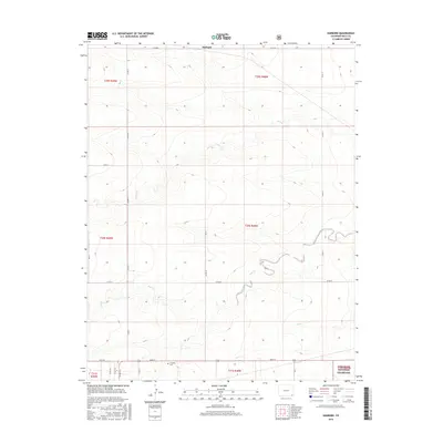
2016 Map of Harbord
USGS Topo · Published 2016About this map
Harbord serves as a central point in this corner of Colorado, where the high plains transition into the protected acreage of the Comanche National Grassland. The landscape is defined by the winding drainage patterns of Plum Creek, Bear Creek, and Cat Creek, which cut through the township grids. These watercourses were vital to the early ranching and agricultural development of Baca County, providing a natural logic to the placement of early routes and homesteads. Local history is anchored by the Pritchett Cemetery, located just south of Main Street, which offers a point of reference for researchers tracing family roots in this rural community. The map's grid of county roads, such as County Road MM and County Road 17, illustrates the systematic organization of the territory into townships like t30s r48w.
Find a feature on this map
27 named features on this map. Tap any name to fly to it.
Don’t see what you’re looking for? This feature index may not catch every label — zoom into the map to look around manually.
Map Details
Editions of this 2016 Harbord Map
This is the sole edition of this map. No revisions or reprints were ever made.
Other maps of this area

1891 · Springfield
USGS Topo · 1:125,000

1892 · Two Butte
USGS Topo · 1:125,000

1893 · Two Butte
USGS Topo · 1:125,000

1893 · Springfield
USGS Topo · 1:125,000

1955 · La Junta
USGS Topo · 1:250,000

1958 · La Junta
USGS Topo · 1:250,000

1968 · La Junta
USGS Topo · 1:250,000
1971 · Big Rock Grange
USGS Topo · 1:24,000
1971 · Mc Endree Ranch
USGS Topo · 1:24,000
1971 · Deora
USGS Topo · 1:24,000