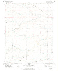
1978 Map of Harbord
USGS Topo · Published 1978About this map
Atchison Topeka and Santa Fe railroad tracks cut across this high plains landscape of Baca County, serving the small siding at Harbord. The terrain is defined by the ephemeral drainage patterns of Plum Creek, Bear Creek, and Cat Creek, which carve gentle draws across the prairie. Evidence of local transport and infrastructure appears in the form of a remote Landing Strip and a modern Pipeline corridor crossing the southwestern sections. Genealogy and local history researchers will find the Pritchett Cem located near the southern boundary, a quiet anchor for the surrounding ranching community. The map also documents several Gravel Pit operations and scattered wells, reflecting the essential water and mineral resource management required in this arid corner of Colorado during the late 1970s.
Find a feature on this map
13 named features on this map. Tap any name to fly to it.
Don’t see what you’re looking for? This feature index may not catch every label — zoom into the map to look around manually.
Map Details
Editions of this 1978 Harbord Map
This is the sole edition of this map. No revisions or reprints were ever made.
Other maps of this area

1891 · Springfield
USGS Topo · 1:125,000

1892 · Two Butte
USGS Topo · 1:125,000

1893 · Two Butte
USGS Topo · 1:125,000

1893 · Springfield
USGS Topo · 1:125,000

1955 · La Junta
USGS Topo · 1:250,000

1958 · La Junta
USGS Topo · 1:250,000

1968 · La Junta
USGS Topo · 1:250,000
1971 · Big Rock Grange
USGS Topo · 1:24,000
1971 · Mc Endree Ranch
USGS Topo · 1:24,000
1971 · Deora
USGS Topo · 1:24,000