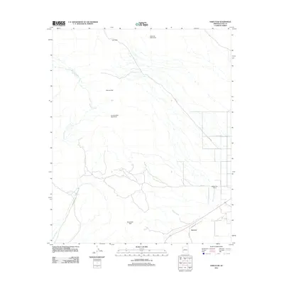
2011 Map of Harcuvar
USGS Topo · Published 2011About this map
Harcuvar sits at the southern edge of this West Arizona landscape, where the flat basin floor meets the rising slopes of the Harcuvar Mountains and the Granite Wash Mountains. This 2011 survey illustrates the modern layout of the McMullen Valley, defined by a sparse but structured network of roads like Hall Ave and Harcuvar Dr that serve the small settlement and the Western Sky Airport. The terrain is shaped by extensive drainage systems, including the Big Granite Wash and Calcite Wash, which flow from the higher elevations of Salome Peak and Winchester Peak. A notable infrastructure feature is the Tank Pass route, which threads through the mountains, following the natural contours of the land. The presence of Canal Bank suggests the importance of water management in this arid environment, highlighting how contemporary settlement patterns in La Paz County remain tied to the surrounding topography and seasonal watercourses.
Find a feature on this map
15 named features on this map. Tap any name to fly to it.
Don’t see what you’re looking for? This feature index may not catch every label — zoom into the map to look around manually.
Map Details
Editions of this 2011 Harcuvar Map
This is the sole edition of this map. No revisions or reprints were ever made.
Other maps of this area

1942 · Vicksburg
USGS Topo · 1:250,000

1954 · Phoenix
USGS Topo · 1:250,000

1957 · Phoenix
USGS Topo · 1:250,000

1958 · Phoenix
USGS Topo · 1:250,000

1960 · Phoenix
USGS Topo · 1:250,000

1961 · Salome
USGS Topo · 1:62,500

1961 · Hope
USGS Topo · 1:62,500
1962 · Utting
USGS Topo · 1:62,500

1962 · Vicksburg
USGS Topo · 1:62,500

1969 · Phoenix
USGS Topo · 1:250,000