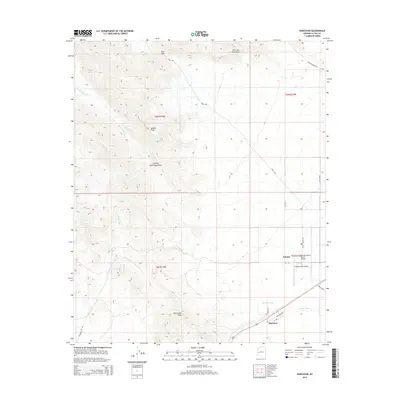
2014 Map of Harcuvar
USGS Topo · Published 2014About this map
The high desert basins and peaks of the Harcuvar Mountains and Granite Wash Mountains dominate this landscape in western Arizona. The settlement of Salome and the adjacent community of Harcuvar sit at the southern edge of the quadrangle, where the valley floor begins to transition toward the higher elevations of Salome Peak and Winchester Peak. This 2014 survey records a network of desert infrastructure, including the Sheepy Hollow Ranch Airport and Western Sky Airpark, alongside ephemeral drainage systems like Big Granite Wash and Calcite Wash. Local transportation is defined by rural corridors such as Harcuvar Dr and Vicksburg Pit Rd, which navigate the arid terrain between mountain passes. The map also delineates topographic features like Tank Pass and Cottonwood Pass, which have historically served as natural gateways through the region's prominent ridgelines.
Find a feature on this map
27 named features on this map. Tap any name to fly to it.
Don’t see what you’re looking for? This feature index may not catch every label — zoom into the map to look around manually.
Map Details
Editions of this 2014 Harcuvar Map
This is the sole edition of this map. No revisions or reprints were ever made.
Other maps of this area

1942 · Vicksburg
USGS Topo · 1:250,000

1954 · Phoenix
USGS Topo · 1:250,000

1957 · Phoenix
USGS Topo · 1:250,000

1958 · Phoenix
USGS Topo · 1:250,000

1960 · Phoenix
USGS Topo · 1:250,000

1961 · Salome
USGS Topo · 1:62,500

1961 · Hope
USGS Topo · 1:62,500
1962 · Utting
USGS Topo · 1:62,500

1962 · Vicksburg
USGS Topo · 1:62,500

1969 · Phoenix
USGS Topo · 1:250,000