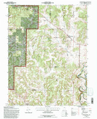
1993 Map of Hardinsburg
USGS Topo · Published 1996About this map
Hardinsburg sits at the intersection of several historic township boundaries and county lines in southern Indiana. The landscape is defined by the sharp transition between the wooded ridges of the Hoosier National Forest and the rolling agricultural lands of Madison and Posey townships. The Blue River carves a dramatic path through the southern portion of the sheet, featuring the prominent Horseshoe Bend and Salt Island.
Find a feature on this map
46 named features on this map. Tap any name to fly to it.
Don’t see what you’re looking for? This feature index may not catch every label — zoom into the map to look around manually.
Map Details
Editions of this 1993 Hardinsburg Map
This is the sole edition of this map. No revisions or reprints were ever made.
Other maps of this area

1946 · Depauw
USGS Topo · 1:24,000

1947 · Hardinsburg
USGS Topo · 1:24,000

1948 · Milltown
USGS Topo · 1:24,000

1949 · Hardinsburg
USGS Topo · 1:24,000

1950 · Becks Mill
USGS Topo · 1:24,000

1950 · Valeene
USGS Topo · 1:24,000

1950 · English
USGS Topo · 1:24,000

1953 · Fredericksburg
USGS Topo · 1:24,000

1956 · Vincennes
USGS Topo · 1:250,000

1957 · Vincennes
USGS Topo · 1:250,000