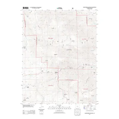
2013 Map of Hardscrabble Mountain
USGS Topo · Published 2013About this map
Hardscrabble Mountain and the high ridges of the Wet Mountains dominate this 2013 survey of the San Isabel National Forest in Custer County. The landscape is defined by its dramatic relief and deep drainages, including Bad Canyon and several named gulches like Rattlesnake Gulch and Bettis Gulch. At the intersection of State Hwy 96 and the Greenhorn Hwy, the small settlement of McKenzie Junction serves as a local navigational node.
Find a feature on this map
61 named features on this map. Tap any name to fly to it.
Don’t see what you’re looking for? This feature index may not catch every label — zoom into the map to look around manually.
Map Details
Editions of this 2013 Hardscrabble Mountain Map
This is the sole edition of this map. No revisions or reprints were ever made.
Other maps of this area

1889 · Canon City
USGS Topo · 1:125,000

1892 · Canon City
USGS Topo · 1:125,000

1954 · Mount Tyndall
USGS Topo · 1:24,000

1954 · Rosita
USGS Topo · 1:24,000

1954 · Pueblo
USGS Topo · 1:250,000

1957 · Pueblo
USGS Topo · 1:250,000

1958 · Pueblo
USGS Topo · 1:250,000

1959 · Rockvale
USGS Topo · 1:24,000

1959 · Royal Gorge
USGS Topo · 1:62,500
1959 · Florence SE
USGS Topo · 1:24,000