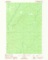
1989 Map of Hardwood Mountain SE
USGS Topo · Published 1989About this map
St John River and its Southwest Branch St John River define the drainage of this Somerset County timberland. The landscape is marked by a network of private roads that serve the local extraction economy, as evidenced by Sand and Gravel Pits and a smaller Gravel Pit to the southeast. The area is divided into unorganized townships, specifically T 8 R 1 8 W E L S and T 7 R 1 8 W E L S. This provisional 1989 survey provides a precise look at the drainage patterns of Brailey Brook and the placement of a Gate on the forest road network, which was essential for managing access during this era of industrial forestry.
Find a feature on this map
10 named features on this map. Tap any name to fly to it.
Don’t see what you’re looking for? This feature index may not catch every label — zoom into the map to look around manually.
Map Details
Editions of this 1989 Hardwood Mountain SE Map
This is the sole edition of this map. No revisions or reprints were ever made.
Other maps of this area

1954 · Baker Lake
USGS Topo · 1:62,500

1954 · St. John Pond
USGS Topo · 1:62,500

1954 · Presque Isle
USGS Topo · 1:250,000

1957 · Norris Brook
USGS Topo · 1:62,500

1957 · Hardwood Mountain
USGS Topo · 1:62,500

1958 · Presque Isle
USGS Topo · 1:250,000

1958 · Saint John Pond
USGS Topo · 1:62,500

1960 · Presque Isle
USGS Topo · 1:250,000

1962 · Baker Lake
USGS Topo · 1:62,500

1962 · Quebec
USGS Topo · 1:250,000