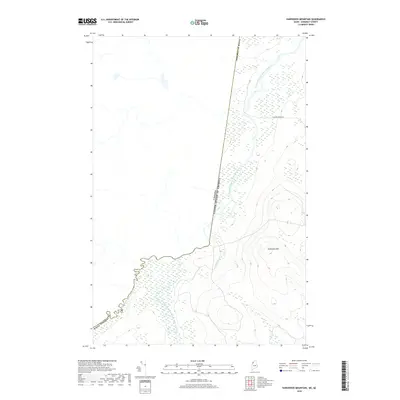
2018 Map of Hardwood Mountain
USGS Topo · Published 2018About this map
The international border between Maine and Quebec bisects this wilderness landscape, following the winding course of the Southwest Branch Saint John River. This 2018 survey reveals a terrain defined by water and forest, where the river serves as a natural boundary before the line cuts straight through the timberlands. To the east, the elevation rises toward Hardwood Mtn, a prominent peak overlooking a network of smaller drainages like Dead Brook and the Little Southwest Branch Saint John River. This remote section of Somerset County contains very little human infrastructure, with Carter Brook Rd providing one of the few named access points into the dense woods near the border.
Find a feature on this map
8 named features on this map. Tap any name to fly to it.
Don’t see what you’re looking for? This feature index may not catch every label — zoom into the map to look around manually.
Map Details
Editions of this 2018 Hardwood Mountain Map
This is the sole edition of this map. No revisions or reprints were ever made.
Other maps of this area

1954 · Baker Lake
USGS Topo · 1:62,500

1954 · Presque Isle
USGS Topo · 1:250,000

1955 · Beaver Pond
USGS Topo · 1:62,500

1957 · Hardwood Mountain
USGS Topo · 1:62,500

1958 · Presque Isle
USGS Topo · 1:250,000

1960 · Presque Isle
USGS Topo · 1:250,000

1962 · Baker Lake
USGS Topo · 1:62,500

1962 · Quebec
USGS Topo · 1:250,000
1986 · Chamberlain Lake
USGS Topo · 1:100,000
1986 · Eastman Brook
USGS Topo · 1:24,000