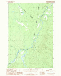
1989 Map of Hardwood Mountain
USGS Topo · Published 1989About this map
The Canada United States border defines the character of this remote northern landscape, where the Southwest Branch St John River serves as a primary geographic artery. In the late 1980s, this region of Somerset County remained largely undeveloped, dominated by the massif of Hardwood Mountain and a complex network of waterways including the Little Southwest Branch and Dead Bk. The map captures the intersection of Maine and Quebec, noted by several French-named features such as Lac Remillard and Ruisseau Doucet that speak to the cross-border cultural history of the North Woods. A single Gravel Pit near the river provides evidence of local industrial activity amidst the vast timberlands and unorganized townships of T 9 R 18 W E L S and T 8 R 18 W E L S. Numerous Rapids along the St. John River highlight the challenging, natural state of the river system during this period.
Find a feature on this map
21 named features on this map. Tap any name to fly to it.
Don’t see what you’re looking for? This feature index may not catch every label — zoom into the map to look around manually.
Map Details
Editions of this 1989 Hardwood Mountain Map
This is the sole edition of this map. No revisions or reprints were ever made.
Other maps of this area

1954 · Baker Lake
USGS Topo · 1:62,500

1954 · Presque Isle
USGS Topo · 1:250,000

1955 · Beaver Pond
USGS Topo · 1:62,500

1957 · Hardwood Mountain
USGS Topo · 1:62,500

1958 · Presque Isle
USGS Topo · 1:250,000

1960 · Presque Isle
USGS Topo · 1:250,000

1962 · Baker Lake
USGS Topo · 1:62,500

1962 · Quebec
USGS Topo · 1:250,000
1986 · Chamberlain Lake
USGS Topo · 1:100,000
1986 · Eastman Brook
USGS Topo · 1:24,000