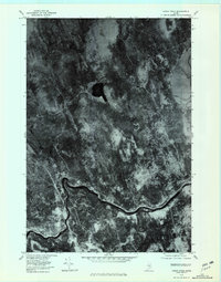
1978 Map of Hardy Pond
USGS Topo · Published 1981About this map
The Piscataquis River meanders through the southern half of this late 1970s orthophotoquad, serving as the primary geographic corridor for the settlements of Medford and Medford Center. This aerial survey provides a clear view of the timbered landscape and water systems that define this part of Maine. The dark, distinct waters of Hardy Pond sit near the center of the sheet, feeding into Hardy Brook as it flows south toward the larger river. To the west, Schoodic Stream cuts through the forest, its course clearly visible against the varying textures of the woodland. The imagery reveals the relationship between the small residential clusters and the surrounding natural resources, highlighting the sparse road network and the dominance of the river-and-stream drainage pattern in this rural area.
Find a feature on this map
6 named features on this map. Tap any name to fly to it.
Don’t see what you’re looking for? This feature index may not catch every label — zoom into the map to look around manually.
Map Details
Editions of this 1978 Hardy Pond Map
This is the sole edition of this map. No revisions or reprints were ever made.
Other maps of this area

1917 · Passadumkeag
USGS Topo · 1:62,500

1933 · Boyd Lake
USGS Topo · 1:62,500

1942 · Lincoln
USGS Topo · 1:62,500

1947 · Schoodic
USGS Topo · 1:62,500

1949 · Schoodic
USGS Topo · 1:62,500

1951 · Boyd Lake
USGS Topo · 1:50,000

1954 · Millinocket
USGS Topo · 1:250,000

1955 · Boyd Lake
USGS Topo · 1:62,500

1957 · Lincoln
USGS Topo · 1:62,500

1958 · Millinocket
USGS Topo · 1:250,000