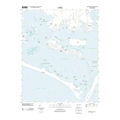
2010 Map of Harkers Island
USGS Topo · Published 2010About this map
Harkers Island and the surrounding maritime landscape of Carteret County are captured here during a period of modern coastal development within the Cape Lookout National Seashore. The map details the intricate relationship between the mainland settlements of Gloucester, Marshallberg, and Straits Haven and the barrier island geography that defines the region. Cultural markers such as the L R Rose Marina and Boatworks signify the local reliance on the water, while family-named landmarks like Gaskill Landing and Sam Winsors Lump offer touchpoints for local genealogists. To the south, the preservation of Shackleford Banks and the Diamond City Hills area contrasts with the residential patterns along Cape Lookout Dr. The transition from the sheltered waters of Back Sound and The Straits to the open Atlantic Ocean illustrates the shifting sands and shoals, including Shep Shoal and The Black Cat, that have historically governed navigation in these North Carolina waters.
Find a feature on this map
78 named features on this map. Tap any name to fly to it.
Don’t see what you’re looking for? This feature index may not catch every label — zoom into the map to look around manually.
Map Details
Editions of this 2010 Harkers Island Map
This is the sole edition of this map. No revisions or reprints were ever made.
Other maps of this area

1949 · Beaufort
USGS Topo · 1:24,000

1949 · Williston
USGS Topo · 1:24,000

1949 · Harkers Island
USGS Topo · 1:24,000

1949 · Davis
USGS Topo · 1:24,000

1949 · Core Creek
USGS Topo · 1:24,000

1950 · Horsepen Point
USGS Topo · 1:24,000

1951 · Williston
USGS Topo · 1:24,000
1951 · Davis
USGS Topo · 1:24,000

1951 · Core Creek
USGS Topo · 1:24,000
1951 · Beaufort
USGS Topo · 1:24,000