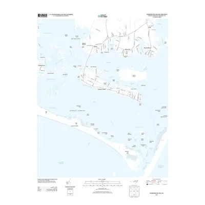
2013 Map of Harkers Island
USGS Topo · Published 2013About this map
Harkers Island serves as the central hub of this coastal survey, linked to the mainland by the bridge at Straits. The landscape is a complex network of sounds and marshes, where the Back Sound meets the Core Sound near Shell Point. To the south, the protective barrier of the Shackleford Banks is detailed, showing the Diamond City Hills and various marshy hammocks like Cedar Hammock and Blinds Hammock. The mainland shore is dotted with established fishing and maritime communities, including Gloucester and Marshallberg, which are situated along the winding banks of Sleepy Creek. This era of the mapping reflects the modern road network of the Crystal Coast, including local connectors like Island Rd and Cape Lookout Dr, while still documenting traditional maritime landmarks like Gaskill Landing and the shifting shoals of Barden Inlet.
Find a feature on this map
155 named features on this map. Tap any name to fly to it.
Don’t see what you’re looking for? This feature index may not catch every label — zoom into the map to look around manually.
Map Details
Editions of this 2013 Harkers Island Map
This is the sole edition of this map. No revisions or reprints were ever made.
Other maps of this area

1949 · Beaufort
USGS Topo · 1:24,000

1949 · Williston
USGS Topo · 1:24,000

1949 · Harkers Island
USGS Topo · 1:24,000

1949 · Davis
USGS Topo · 1:24,000

1949 · Core Creek
USGS Topo · 1:24,000

1950 · Horsepen Point
USGS Topo · 1:24,000

1951 · Williston
USGS Topo · 1:24,000
1951 · Davis
USGS Topo · 1:24,000

1951 · Core Creek
USGS Topo · 1:24,000
1951 · Beaufort
USGS Topo · 1:24,000