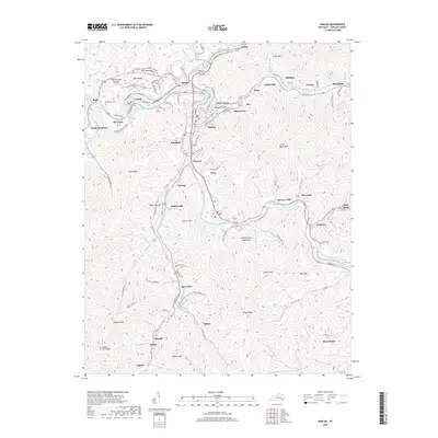
2019 Map of Harlan
USGS Topo · Published 2019About this map
Harlan serves as the central hub where the forks of the Cumberland River converge, framed by the formidable rises of Pine Mountain to the north and Cumberland Mountain to the south. This 2019 survey captures a landscape deeply defined by its industrial and residential patterns, showing how settlements like Loyall, Baxter, and Clowertown follow the narrow river valleys. The convergence of the Clover Fork Cumberland River and the Martins Fork Cumberland River at Harlan illustrates the traditional mountain geography where town sites were dictated by available flat land along the water. Further up the hollows, small communities such as Mary Alice, Yancey, and Three Point remain connected to the central valley. Local history is anchored by sites like Beech Grove Cem, Resthaven Cem, and the Tucker-Guthrie Memorial Airport, alongside legacy place names like Farmers Mill and Harlan Gas that hint at the region's productive past.
Find a feature on this map
154 named features on this map. Tap any name to fly to it.
Don’t see what you’re looking for? This feature index may not catch every label — zoom into the map to look around manually.
Map Details
Editions of this 2019 Harlan Map
This is the sole edition of this map. No revisions or reprints were ever made.
Other maps of this area

1887 · Jonesville
USGS Topo · 1:125,000

1891 · Jonesville
USGS Topo · 1:125,000

1903 · Harlan
USGS Topo · 1:48,000

1916 · Harlan
USGS Topo · 1:48,000

1916 · Nolansburg
USGS Topo · 1:48,000

1919 · Nolansburg
USGS Topo · 1:62,500

1919 · Harlan
USGS Topo · 1:62,500

1932 · Hagan
USGS Topo · 1:62,500
1935 · Ewing
USGS Topo · 1:24,000

1935 · Hubbard Springs
USGS Topo · 1:24,000