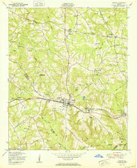
1950 Map of Harlem
USGS Topo · Published 1950About this map
Harlem serves as the focal point for this 1950 survey, where the Georgia railroad cuts a straight path through the heart of town. The surrounding landscape in Columbia Co and McDuffie Co is defined by a dense network of country churches and small rural settlements like Pumpkin Center, Sawdust, and Campania. This era represents a transition in rural education and community life, evidenced by the presence of Harlem Elementary and Junior High School and several local institutions such as Piney Grove Church and School and the Philadelphia Church.
Find a feature on this map
49 named features on this map. Tap any name to fly to it.
Don’t see what you’re looking for? This feature index may not catch every label — zoom into the map to look around manually.
Map Details
Editions of this 1950 Harlem Map
This is the sole edition of this map. No revisions or reprints were ever made.
Other maps of this area

1892 · Mc Cormick
USGS Topo · 1:125,000

1912 · Mc Cormick
USGS Topo · 1:125,000

1920 · Clarks Hill
USGS Topo · 1:48,000

1921 · Clarks Hill
USGS Topo · 1:62,500

1921 · Appling
USGS Topo · 1:62,500

1922 · Harlem
USGS Topo · 1:62,500

1922 · Hephzibah
USGS Topo · 1:62,500

1941 · Clarks Hill
USGS Topo · 1:62,500

1942 · Clarks Hill
USGS Topo · 1:62,500

1943 · Appling
USGS Topo · 1:62,500