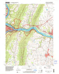
1996 Map of Harpers Ferry
USGS Topo · Published 2001About this map
The confluence of the Potomac River and Shenandoah River anchor this late-century survey, a landscape where the tri-state boundaries of West Virginia, Maryland, and Virginia meet. The steep ridges of Elk Ridge and the Blue Ridge overlook the strategic mountain gap at Harpers Ferry, while the historic Chesapeake and Ohio Canal and B & O RR parallel the northern riverbank.
Find a feature on this map
65 named features on this map. Tap any name to fly to it.
Don’t see what you’re looking for? This feature index may not catch every label — zoom into the map to look around manually.
Map Details
Editions of this 1996 Harpers Ferry Map
This is the sole edition of this map. No revisions or reprints were ever made.
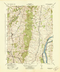
Other maps of this area

1884 · Harpers Ferry
USGS Topo · 1:125,000

1891 · Harpers Ferry
USGS Topo · 1:125,000

1893 · Harpers Ferry
USGS Topo · 1:125,000

1908 · Middletown
USGS Topo · 1:48,000

1910 · Antietam
USGS Topo · 1:62,500

1914 · Martinsburg
USGS Topo · 1:48,000

1916 · Martinsburg
USGS Topo · 1:62,500

1916 · Berryville
USGS Topo · 1:62,500

1939 · Berryville
USGS Topo · 1:48,000
1944 · Waterford
USGS Topo · 1:31,680