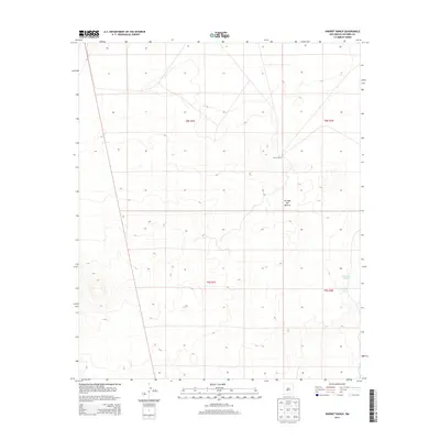
2013 Map of Harriet Ranch
USGS Topo · Published 2013About this map
Jornada del Muerto dominates the terrain of this 2013 survey in Socorro County, New Mexico. This portion of the expansive high desert basin shows a landscape characterized by intermittent water features and isolated ranching activity. The settlement at Harriet Ranch serves as a primary landmark in a region defined by its wide, open drainage patterns and subtle elevation shifts. Toward the eastern edge of the quadrangle, Lambing Lake and Lambing Tank provide evidence of water management and seasonal hydrology essential for livestock and local wildlife. The map captures the Public Land Survey System divisions between t8s r1e and t9s r2e, illustrating the geometric grid overlaid on this arid environment during the early 21st century.
Find a feature on this map
8 named features on this map. Tap any name to fly to it.
Don’t see what you’re looking for? This feature index may not catch every label — zoom into the map to look around manually.
Map Details
Editions of this 2013 Harriet Ranch Map
This is the sole edition of this map. No revisions or reprints were ever made.
Other maps of this area

1916 · Salinas Peak
USGS Topo · 1:125,000

1948 · Granjean Well
USGS Topo · 1:62,500

1948 · Val Verde
USGS Topo · 1:62,500

1948 · Malpais Well
USGS Topo · 1:62,500

1948 · Salinas Peak
USGS Topo · 1:62,500

1954 · Tularosa
USGS Topo · 1:250,000

1958 · Tularosa
USGS Topo · 1:250,000

1981 · Granjean Well
USGS Topo · 1:24,000

1981 · Tularosa
USGS Topo · 1:100,000
1981 · Blakemore Well
USGS Topo · 1:24,000