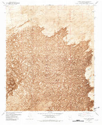
1981 Map of Harriet Ranch
USGS Topo · Published 1982About this map
The stark volcanic expanse of the Lava fields dominates this Socorro County landscape, offering a detailed look at the geological and ranching history of the Pedro Armendaris grant area. In the early 1980s, these lands were primarily defined by the infrastructure of remote ranching, centered on locations like Harriet Ranch and essential water sources such as Lavaflow Tank and Malpais Well. The presence of several Caves and a singular Cave within the lava flow highlights the complex subterranean geography of the region, while a Drill Hole and the presence of a Corral signify the ongoing human efforts to manage livestock in this arid environment. Transportation through this challenging terrain is limited, primarily following the path of the Govt Rd as it skirts the northern edge of the volcanic deposits.
Find a feature on this map
11 named features on this map. Tap any name to fly to it.
Don’t see what you’re looking for? This feature index may not catch every label — zoom into the map to look around manually.
Map Details
Editions of this 1981 Harriet Ranch Map
This is the sole edition of this map. No revisions or reprints were ever made.
Other maps of this area

1916 · Salinas Peak
USGS Topo · 1:125,000

1948 · Granjean Well
USGS Topo · 1:62,500

1948 · Val Verde
USGS Topo · 1:62,500

1948 · Malpais Well
USGS Topo · 1:62,500

1948 · Salinas Peak
USGS Topo · 1:62,500

1954 · Tularosa
USGS Topo · 1:250,000

1958 · Tularosa
USGS Topo · 1:250,000

1981 · Granjean Well
USGS Topo · 1:24,000

1981 · Tularosa
USGS Topo · 1:100,000
1981 · Blakemore Well
USGS Topo · 1:24,000