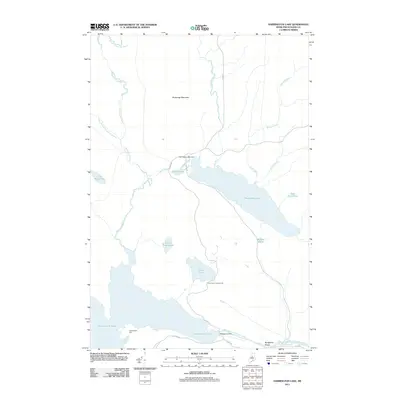
2011 Map of Harrington Lake
USGS Topo · Published 2011About this map
Chesuncook Lake and the West Branch Penobscot River dominate this interior landscape, illustrating a region defined by industrial water management and logging access. The presence of multiple barriers, including Chesuncook Dam, Ripogenus Dam, and the smaller Harrington Lake Dam, speaks to the engineering required to harness the region's vast hydrographic network. Further north, Soubunge Mountain rises above a series of drainages like Ripogenus Stream and Soper Brook. Local infrastructure is represented by the Lily Bay Rd and Telos Rd, providing access to remote points such as the Frost Pond Campground. The transition from the broad waters of Harrington Lake to the narrow, steep descent of Ripogenus Gorge highlights the significant elevation changes that shaped early river-driving and later power generation in this part of Piscataquis County.
Find a feature on this map
24 named features on this map. Tap any name to fly to it.
Don’t see what you’re looking for? This feature index may not catch every label — zoom into the map to look around manually.
Map Details
Editions of this 2011 Harrington Lake Map
This is the sole edition of this map. No revisions or reprints were ever made.
Other maps of this area

1953 · Telos Lake
USGS Topo · 1:62,500

1954 · Chesuncook
USGS Topo · 1:62,500

1954 · Grant Farm
USGS Topo · 1:62,500

1954 · Harrington Lake
USGS Topo · 1:62,500

1954 · Presque Isle
USGS Topo · 1:250,000

1954 · Millinocket
USGS Topo · 1:250,000

1957 · Telos Lake
USGS Topo · 1:62,500

1958 · Presque Isle
USGS Topo · 1:250,000

1958 · Millinocket
USGS Topo · 1:250,000

1958 · Chesuncook
USGS Topo · 1:62,500