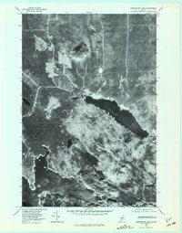
1978 Map of Harrington Lake
USGS Topo · Published 1981About this map
Chesuncook Dam controls the flow where the massive waters of Chesuncook Lake and Ripogenus Lake meet, a critical node in the timber and hydroelectric geography of the North Maine Woods. This 1978 orthophotoquad captures the landscape as a working forest, showing the stark contrast between the deep waters of Harrington Lake and the surrounding timberlands marked by logging activity. The West Branch Penobscot River winds through the lower portion of the sheet, historically serving as a primary artery for log drives. To the north, the elevation rises toward Soubunge Mountain, overlooking a network of smaller drainages like Soper Brook and Ripogenus Stream. The aerial imagery reveals the geometric patterns of forest management and access roads that define the region's mid-century economy.
Find a feature on this map
9 named features on this map. Tap any name to fly to it.
Don’t see what you’re looking for? This feature index may not catch every label — zoom into the map to look around manually.
Map Details
Editions of this 1978 Harrington Lake Map
This is the sole edition of this map. No revisions or reprints were ever made.
Other maps of this area

1953 · Telos Lake
USGS Topo · 1:62,500

1954 · Chesuncook
USGS Topo · 1:62,500

1954 · Grant Farm
USGS Topo · 1:62,500

1954 · Harrington Lake
USGS Topo · 1:62,500

1954 · Presque Isle
USGS Topo · 1:250,000

1954 · Millinocket
USGS Topo · 1:250,000

1957 · Telos Lake
USGS Topo · 1:62,500

1958 · Presque Isle
USGS Topo · 1:250,000

1958 · Millinocket
USGS Topo · 1:250,000

1958 · Chesuncook
USGS Topo · 1:62,500