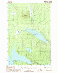
1988 Map of Harrington Lake
USGS Topo · Published 1988About this map
Soubunge Mountain anchors the north-central terrain of this Piscataquis County landscape, a region defined by its vast interconnected waterways and timber-management boundaries. The southern portion of the map showcases the critical hydraulic infrastructure of the late 20th century, including the Ripogenus Dam and Chesuncook Dam which regulate the flow between Ripogenus Lake and Chesuncook Lake. The West Branch Penobscot River cuts through the southeast corner, emerging from the dramatic Ripogenus Gorge. The map records a wilderness divided by the Monument Line and various township ranges such as T 3 R 12 W E L S, where a network of private roads provides access to isolated water bodies like Brighton Deadwater and Harrington Lake. This documentation of the Maine woods during the 1980s illustrates the scale of logging infrastructure and water control necessary to manage the Penobscot watershed.
Find a feature on this map
27 named features on this map. Tap any name to fly to it.
Don’t see what you’re looking for? This feature index may not catch every label — zoom into the map to look around manually.
Map Details
Editions of this 1988 Harrington Lake Map
This is the sole edition of this map. No revisions or reprints were ever made.
Other maps of this area

1953 · Telos Lake
USGS Topo · 1:62,500

1954 · Chesuncook
USGS Topo · 1:62,500

1954 · Grant Farm
USGS Topo · 1:62,500

1954 · Harrington Lake
USGS Topo · 1:62,500

1954 · Presque Isle
USGS Topo · 1:250,000

1954 · Millinocket
USGS Topo · 1:250,000

1957 · Telos Lake
USGS Topo · 1:62,500

1958 · Presque Isle
USGS Topo · 1:250,000

1958 · Millinocket
USGS Topo · 1:250,000

1958 · Chesuncook
USGS Topo · 1:62,500