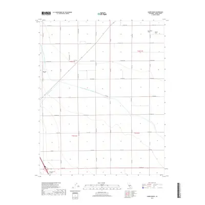
2018 Map of Harris Ranch
USGS Topo · Published 2018About this map
San Joaquin Valley agriculture dominates this landscape within the larger Central Valley region of Fresno County. The map highlights the essential water infrastructure required for large-scale farming, specifically the Governor Edmund G Brown California Aqueduct and the Coalinga Canal, which cut across the grid of rural roads and section lines. The named Harris Ranch operations serve as a focal point, supported by aviation facilities including the Harris Ranch Airport and the nearby Agro-West Airport. This 2018 survey illustrates a highly organized industrial agricultural system, where a network of precisely laid out roads such as W Jeffrey Ave, S El Dorado Ave, and W Dorris Ave provides access to vast tracts of irrigated land.
Find a feature on this map
27 named features on this map. Tap any name to fly to it.
Don’t see what you’re looking for? This feature index may not catch every label — zoom into the map to look around manually.
Map Details
Editions of this 2018 Harris Ranch Map
This is the sole edition of this map. No revisions or reprints were ever made.
Other maps of this area

1912 · Coalinga
USGS Topo · 1:125,000

1928 · Delta Farms No 3
USGS Topo · 1:31,680

1931 · Wheatville
USGS Topo · 1:31,680

1931 · Towne Oil Station
USGS Topo · 1:31,680

1931 · Mouth of Cantua Creek
USGS Topo · 1:31,680

1932 · Delta Farms
USGS Topo · 1:31,680

1932 · West of Lethent
USGS Topo · 1:31,680

1933 · Huron
USGS Topo · 1:31,680

1933 · Guijarral Hills
USGS Topo · 1:31,680
1936 · Guijarral Hills
USGS Topo · 1:31,680