
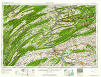
1961 Map of Harrisburg
USGS Topo · Published 1961About this map
The Susquehanna River carves a dramatic path through the ridge-and-valley province, serving as the primary corridor for central Pennsylvania's development. This mid-century view highlights the concentration of political and industrial power at the State Capitol in Harrisburg, where the Pennsylvania RR and Reading RR converge. To the south, the agricultural wealth of Lancaster and Lebanon is evident, while the northern reaches of the map show the transition into the Anthracite Coal Fields near Shamokin and Mount Carmel. Significant military and educational footprints appear at Carlisle Barracks, Indiantown Gap Military Reservation, and Pennsylvania State University. The transport network shows a maturing post-war infrastructure, featuring the Pennsylvania Turnpike and the Lincoln Highway threading through gaps in the Blue Mountain and Kittatinny Mountain ridges.
Find a feature on this map
158 named features on this map. Tap any name to fly to it.
Don’t see what you’re looking for? This feature index may not catch every label — zoom into the map to look around manually.
Map Details
Editions of this 1961 Harrisburg Map
2 editions found
Other maps of this area

1889 · Catawissa
USGS Topo · 1:62,500

1889 · Hazleton
USGS Topo · 1:62,500

1889 · Pottsville
USGS Topo · 1:62,500

1891 · Wilkesbarre
USGS Topo · 1:62,500

1891 · Hazleton
USGS Topo · 1:62,500

1891 · Pottsville
USGS Topo · 1:62,500

1891 · Lebanon
USGS Topo · 1:62,500

1892 · Catawissa
USGS Topo · 1:62,500

1892 · Lykens
USGS Topo · 1:62,500

1892 · Hummelstown
USGS Topo · 1:62,500