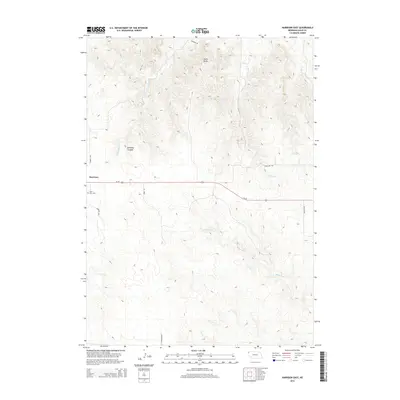
2014 Map of Harrison East
USGS Topo · Published 2014About this map
Harrison stands at the western edge of this High Plains landscape, situated where the open prairie begins its descent into the broken breaks of the Pine Ridge country. The village is flanked by the quiet grounds of Saint Mary Cem just to the south, while the main artery of Us-20 cuts a straight path eastward across the drainages. North of the settlement, the terrain becomes dramatically more complex, marked by the distinctive elevation of Pants Butte and the winding depths of Sowbelly Canyon. These topographic features define a network of watercourses including Sowbelly Cr and the multiple forks of Hat Creek, such as W Hat Cr and E Hat Cr. The southern portion of the map is dominated by the headwaters of the White River, showing a transition from the agricultural plateaus near Harrison to the eroded valley systems that characterize this part of Sioux County.
Find a feature on this map
15 named features on this map. Tap any name to fly to it.
Don’t see what you’re looking for? This feature index may not catch every label — zoom into the map to look around manually.
Map Details
Editions of this 2014 Harrison East Map
This is the sole edition of this map. No revisions or reprints were ever made.
Other maps of this area

1955 · Alliance
USGS Topo · 1:250,000

1957 · Alliance
USGS Topo · 1:250,000

1958 · Alliance
USGS Topo · 1:250,000

1978 · Harrison West
USGS Topo · 1:24,000

1979 · Harrison SE
USGS Topo · 1:24,000
1979 · Harrison SW
USGS Topo · 1:24,000

1979 · Harrison East
USGS Topo · 1:24,000

1980 · Kyle Creek
USGS Topo · 1:24,000

1980 · Five Points
USGS Topo · 1:24,000

1980 · Andrews
USGS Topo · 1:24,000