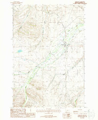
1988 Map of Harrison
USGS Topo · Published 1988About this map
The town of Harrison serves as the focal point of this late-20th-century landscape, positioned at a critical junction where agricultural water management meets heavy rail infrastructure. The Burlington Northern railroad corridor and the And Robert Grade underscore the area's logistical importance, while a complex network of irrigation features like the Missouri Ditch and Warren Ditch speak to the engineering required to sustain Madison County ranching.
Find a feature on this map
19 named features on this map. Tap any name to fly to it.
Don’t see what you’re looking for? This feature index may not catch every label — zoom into the map to look around manually.
Map Details
Editions of this 1988 Harrison Map
This is the sole edition of this map. No revisions or reprints were ever made.
Other maps of this area

1888 · Three Forks
USGS Topo · 1:250,000

1894 · Three Forks
USGS Topo · 1:250,000

1895 · Three Forks
USGS Topo · 1:250,000

1947 · Bozeman
USGS Topo · 1:250,000

1948 · Bozeman
USGS Topo · 1:250,000

1949 · Norris
USGS Topo · 1:62,500

1950 · Three Forks
USGS Topo · 1:62,500

1950 · Jefferson Island
USGS Topo · 1:62,500

1950 · Harrison
USGS Topo · 1:62,500

1951 · Norris
USGS Topo · 1:62,500