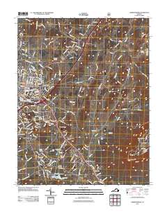
2011 Map of Harrisonburg
USGS Topo · Published 2011About this map
Harrisonburg serves as the focal point of this Shenandoah Valley study, showing the city's modern footprint alongside neighboring communities like Preston Heights and Ashby Heights. The urban landscape is anchored by the James Madison University campus and a dense collection of historic burial grounds, including the Newton Cemetery, Hebrew Cemetery, and Woodbine Cemetery. Moving east from the city center, the terrain rises toward Chestnut Ridge and the prominent Massanutten Peak, where the Massanutten Resort and a natural formation known as The Kettle mark the transition into the mountain range.
Find a feature on this map
190 named features on this map. Tap any name to fly to it.
Don’t see what you’re looking for? This feature index may not catch every label — zoom into the map to look around manually.
Map Details
Editions of this 2011 Harrisonburg Map
This is the sole edition of this map. No revisions or reprints were ever made.
Other maps of this area

1892 · Woodstock
USGS Topo · 1:125,000

1892 · Harrisonburg
USGS Topo · 1:125,000

1937 · Elkton
USGS Topo · 1:62,500

1941 · Harrisonburg
USGS Topo · 1:62,500

1942 · Mt Jackson
USGS Topo · 1:62,500

1943 · Harrisonburg
USGS Topo · 1:62,500

1946 · Mt Jackson
USGS Topo · 1:62,500

1947 · Mt Jackson
USGS Topo · 1:62,500

1947 · Broadway
USGS Topo · 1:62,500

1949 · Charlottesville
USGS Topo · 1:250,000