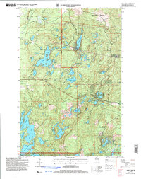
2005 Map of Hart Lake
USGS Topo · Published 2006About this map
Glacial kettle lakes and dense woodlands dominate this portion of the Chequamegon Nicolet National Forest south of Lake Superior. The landscape is defined by its complex hydrology, featuring numerous water bodies such as Long Lake, Hart Lake, and the smaller Lake Nokomis. The northern portion of the map transitions into the Moquah Barrens Area, a distinctive pine barrens ecosystem. This era reflects a landscape managed for both timber and recreation, evidenced by the Tri-County Recreation Corridor and various boat access points. Human infrastructure is sparse but strategic, including a Pumping Station, the Iron River Lookout Iron, and an old Battleax Grade that hints at the region's logging history and early transport network. Boundary lines for the towns of Tripp, Barksdale, Iron River, and Keystone intersect here, showing the administrative division of this wooded lake country.
Find a feature on this map
54 named features on this map. Tap any name to fly to it.
Don’t see what you’re looking for? This feature index may not catch every label — zoom into the map to look around manually.
Map Details
Editions of this 2005 Hart Lake Map
This is the sole edition of this map. No revisions or reprints were ever made.
Other maps of this area

1943 · Iron Lake
USGS Topo · 1:48,000

1944 · Moquah
USGS Topo · 1:48,000

1944 · Drummond
USGS Topo · 1:48,000

1944 · Grandview
USGS Topo · 1:48,000

1947 · Drummond
USGS Topo · 1:48,000

1947 · Moquah
USGS Topo · 1:48,000

1947 · Iron Lake
USGS Topo · 1:48,000

1947 · Grandview
USGS Topo · 1:48,000

1953 · Ashland
USGS Topo · 1:250,000

1958 · Ashland
USGS Topo · 1:250,000