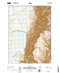
2020 Map of Hart Lake
USGS Topo · Published 2020About this map
Hart Mtn dominates the eastern landscape of this Lake County region, rising sharply above the desert floor and its interconnected basin of seasonal waters. The western half of the terrain is defined by the expansive bed of Hart Lake, which is fed by drainage from the higher plateau including Guano Slough and Warner Cr. This area illustrates the characteristic basin-and-range topography of southeastern Oregon, where steep escarpments are deeply incised by drainage systems such as De Garmo Canyon, Arsenic Canyon, and Potter Canyon. High-altitude water sources like Vinyard Lake and Anderson Lake dot the northern flats, while the solitary Hart Mountain Rd provides the primary access route through this high-desert environment. The map details the complex drainage patterns of Norton Cr, Stockade Cr, and Goat Cr as they flow from the rugged mountain face toward the lake bed below.
Find a feature on this map
22 named features on this map. Tap any name to fly to it.
Don’t see what you’re looking for? This feature index may not catch every label — zoom into the map to look around manually.
Map Details
Editions of this 2020 Hart Lake Map
This is the sole edition of this map. No revisions or reprints were ever made.
Other maps of this area

1955 · Adel
USGS Topo · 1:250,000

1957 · Adel
USGS Topo · 1:250,000

1958 · Adel
USGS Topo · 1:250,000

1962 · Adel
USGS Topo · 1:250,000

1967 · Flagstaff Lake
USGS Topo · 1:24,000

1967 · Jacobs Reservoir
USGS Topo · 1:24,000

1967 · Plush
USGS Topo · 1:24,000

1967 · Rabbit Hills SW
USGS Topo · 1:24,000

1967 · Priday Reservoir
USGS Topo · 1:24,000

1967 · Campbell Lake
USGS Topo · 1:24,000