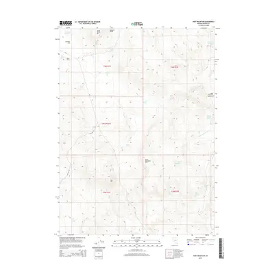
2015 Map of Hart Mountain
USGS Topo · Published 2015About this map
Hart Mtn and the Massacre Range dominate this high-desert landscape in Washoe County, where survival was historically dictated by scattered water sources. The map reveals a network of springs and man-made catchments essential for ranching and wildlife in this arid territory. Water features like Americum Reservoir and Little Mahogany Reservoir appear alongside numerous named springs, such as Harts Springs and Nellie Spring. The terrain transitions from the broad Antelope Flat to prominent peaks like Nellie Spring Mtn. Access is limited to remote corridors like CR-34 and Hart Camp Rd, reflecting the isolation of this corner of Nevada. This survey provides a precise record of the hydrological infrastructure, including the Big Wiemer Spring and Wagontire Spring, that defines land use in the Great Basin.
Find a feature on this map
31 named features on this map. Tap any name to fly to it.
Don’t see what you’re looking for? This feature index may not catch every label — zoom into the map to look around manually.
Map Details
Editions of this 2015 Hart Mountain Map
This is the sole edition of this map. No revisions or reprints were ever made.
Other maps of this area

1889 · Long Valley
USGS Topo · 1:250,000

1954 · Vya
USGS Topo · 1:250,000

1958 · Vya
USGS Topo · 1:250,000

1962 · Vya
USGS Topo · 1:250,000

1972 · Mahogany Mtn
USGS Topo · 1:24,000
1972 · Yellow Hills West
USGS Topo · 1:24,000

1978 · Hart Mountain
USGS Topo · 1:24,000
1979 · Powers Well
USGS Topo · 1:24,000
1979 · Nellie Spring Mtn
USGS Topo · 1:24,000

1979 · Butte Spring
USGS Topo · 1:24,000