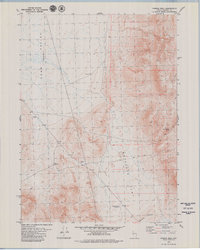
1979 Map of Powers Well
USGS Topo · Published 1979About this map
Powers Well sits as a central water source in this high desert landscape of Washoe County, where the terrain transitions from the broad Long Valley (Depression) into the elevated reaches of Antelope Flat. This late 1970s survey captures a working ranching environment defined by vital water points and livestock infrastructure, including the 3-C Windmill and the specifically named Cold Weather Reservoir. The landscape is etched by a network of primitive Jeep Trails that negotiate the slopes of Crabapple Ridge, providing the primary means of movement through this sparsely populated territory. Several benchmarks, such as BM 5594 and BM 5721, provide precise elevation data for land surveyors and researchers tracing historic property boundaries. The presence of a Borrow Pit and the secluded Lone Jumper Spring further illustrate the localized human footprint on this otherwise remote Nevada landscape.
Find a feature on this map
18 named features on this map. Tap any name to fly to it.
Don’t see what you’re looking for? This feature index may not catch every label — zoom into the map to look around manually.
Map Details
Editions of this 1979 Powers Well Map
2 editions found
Other maps of this area

1889 · Long Valley
USGS Topo · 1:250,000

1954 · Vya
USGS Topo · 1:250,000

1958 · Vya
USGS Topo · 1:250,000

1962 · Vya
USGS Topo · 1:250,000

1966 · Vya
USGS Topo · 1:24,000

1966 · Massacre Creek
USGS Topo · 1:24,000

1966 · Painted Point
USGS Topo · 1:24,000

1978 · Hart Mountain
USGS Topo · 1:24,000
1979 · Nellie Spring Mtn
USGS Topo · 1:24,000
1979 · Boulder Lake
USGS Topo · 1:24,000