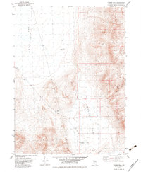
1979 Map of Powers Well
USGS Topo · Published 1982About this map
Long Valley (Depression) dominates the western landscape of this Washoe County survey, characterized by a distinct topographic sink that transition eastward into the elevated terrain of Antelope Flat. The map documents a sparse, high-desert environment where water sources are vital but rare markers on the land. Key water points include Lone Juniper Spring and the Cold Weather Reservoir, essential infrastructure for the region's ranching or migratory needs. The presence of Powers Well and a isolated Windmill further emphasizes the reliance on groundwater in this arid territory. Human activity is represented by utilitarian infrastructure rather than permanent settlements, with the landscape crisscrossed by a Jeep Trail and a noted Borrow Pit. Detailed bench marks like BM 5686 and BM 5721 provide precise elevations for researchers studying the geomorphology of the Great Basin.
Find a feature on this map
17 named features on this map. Tap any name to fly to it.
Don’t see what you’re looking for? This feature index may not catch every label — zoom into the map to look around manually.
Map Details
Editions of this 1979 Powers Well Map
2 editions found
Other maps of this area

1889 · Long Valley
USGS Topo · 1:250,000

1954 · Vya
USGS Topo · 1:250,000

1958 · Vya
USGS Topo · 1:250,000

1962 · Vya
USGS Topo · 1:250,000

1966 · Vya
USGS Topo · 1:24,000

1966 · Massacre Creek
USGS Topo · 1:24,000

1966 · Painted Point
USGS Topo · 1:24,000

1978 · Hart Mountain
USGS Topo · 1:24,000
1979 · Powers Well
USGS Topo · 1:24,000
1979 · Nellie Spring Mtn
USGS Topo · 1:24,000