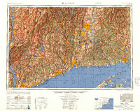
1947 Map of Hartford
USGS Topo · Published 1956About this map
The Connecticut River valley and the industrial shoreline of Long Island Sound dominate this mid-century portrait of southern New England and the Hudson Highlands. Post-war urbanization is clearly visible as the built-up areas of Hartford, New Haven, and Bridgeport expand along established transit corridors. The map documents an era when the New York New Haven & Hartford RR and the New York Central RR remained the primary arteries for commerce and travel, while the burgeoning state highway system began to reshape the landscape between established towns like Waterbury and Danbury. To the west, the Hudson River carves through the Catskill Mountains, highlighting the massive Ashokan Reservoir and the preserved wilderness of Catskill State Park. Coastal military sites, including Fort Terry and Camp Shanks, reflect the recent wartime footprint on the region's geography.
Find a feature on this map
308 named features on this map. Tap any name to fly to it.
Don’t see what you’re looking for? This feature index may not catch every label — zoom into the map to look around manually.
Map Details
Editions of this 1947 Hartford Map
2 editions found

Other maps of this area

1885 · Sheffield
USGS Topo · 1:62,500

1886 · Springfield
USGS Topo · 1:62,500

1887 · Brookfield
USGS Topo · 1:62,500

1887 · Palmer
USGS Topo · 1:62,500

1887 · Granville
USGS Topo · 1:62,500

1888 · Sheffield
USGS Topo · 1:62,500

1888 · Sandisfield
USGS Topo · 1:62,500

1888 · Paterson
USGS Topo · 1:62,500

1889 · Springfield
USGS Topo · 1:62,500

1889 · Stonington
USGS Topo · 1:62,500