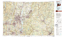
1994 Map of Hartford
USGS Topo · Published 1995About this map
The Connecticut River serves as the central artery of this region, shaping the industrial and residential development of the capital at Hartford and neighboring East Hartford. By the mid-1990s, the urban corridor between New Britain and Manchester was a complex network of transit, featuring the Interstate 84 and Interstate 91 interchange. Significant institutional landmarks include the State Capitol, Trinity College, and the sprawling University of Connecticut campus at Storrs.
Find a feature on this map
66 named features on this map. Tap any name to fly to it.
Don’t see what you’re looking for? This feature index may not catch every label — zoom into the map to look around manually.
Map Details
Editions of this 1994 Hartford Map
2 editions found
Other maps of this area

1886 · Springfield
USGS Topo · 1:62,500

1887 · Brookfield
USGS Topo · 1:62,500

1887 · Palmer
USGS Topo · 1:62,500

1887 · Granville
USGS Topo · 1:62,500

1888 · Sandisfield
USGS Topo · 1:62,500

1889 · Springfield
USGS Topo · 1:62,500

1889 · Stonington
USGS Topo · 1:62,500

1889 · Derby
USGS Topo · 1:62,500

1889 · Webster
USGS Topo · 1:62,500

1889 · Putnam
USGS Topo · 1:62,500