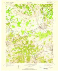
1954 Map of Hartford
USGS Topo · Published 1956About this map
Hartford and the surrounding coalfields of Ohio County are captured in this mid-century topographic record, showing a landscape defined by the winding Rough River and the industrial infrastructure of the day. The map documents an area where agriculture and heavy industry converged, featuring extensive Strip Mines and the Taylor Mines settlement south of Beaver Dam. This period highlights the critical role of rail transport, with the Louisville and Nashville and Illinois Central railroads connecting the small mining and farming communities that dot the terrain.
Find a feature on this map
38 named features on this map. Tap any name to fly to it.
Don’t see what you’re looking for? This feature index may not catch every label — zoom into the map to look around manually.
Map Details
Editions of this 1954 Hartford Map
This is the sole edition of this map. No revisions or reprints were ever made.
Other maps of this area

1906 · Sutherland
USGS Topo · 1:62,500

1907 · Whitesville
USGS Topo · 1:62,500

1909 · Whitesville
USGS Topo · 1:62,500

1909 · Hartford
USGS Topo · 1:62,500

1909 · Central City
USGS Topo · 1:62,500

1952 · Equality
USGS Topo · 1:24,000

1953 · Central City East
USGS Topo · 1:24,000

1953 · Utica
USGS Topo · 1:24,000

1953 · Dundee
USGS Topo · 1:24,000

1953 · Pleasant Ridge
USGS Topo · 1:24,000