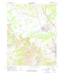
1973 Map of Hartford
USGS Topo · Published 1975About this map
Hartford and Beaver Dam serve as the primary hubs in this Ohio County landscape, where the Rough River winds through the northern half of the quadrangle. By the mid-1970s, the region's economy is clearly defined by heavy industry and transit, with numerous Strip Mine operations and Tailing Ponds marking the terrain south of the river. The Louisville And Nashville and Illinois Central Gulf Railroad provide the rail backbone for the area, connecting settlements like McHenry and Taylor Mines. For the local historian, the map preserves the location of several smaller communities and landmarks, such as No Creek, Centertown, and West Providence. Numerous family and community burial grounds, including Old Mill Cem, Alexander Cem, and Carson Cem, are documented alongside rural institutions like Goshen Ch and Central Grove Ch.
Find a feature on this map
61 named features on this map. Tap any name to fly to it.
Don’t see what you’re looking for? This feature index may not catch every label — zoom into the map to look around manually.
Map Details
Editions of this 1973 Hartford Map
This is the sole edition of this map. No revisions or reprints were ever made.
Other maps of this area

1906 · Sutherland
USGS Topo · 1:62,500

1907 · Whitesville
USGS Topo · 1:62,500

1909 · Whitesville
USGS Topo · 1:62,500

1909 · Hartford
USGS Topo · 1:62,500

1909 · Central City
USGS Topo · 1:62,500

1952 · Equality
USGS Topo · 1:24,000

1953 · Central City East
USGS Topo · 1:24,000

1953 · Utica
USGS Topo · 1:24,000

1953 · Dundee
USGS Topo · 1:24,000

1953 · Pleasant Ridge
USGS Topo · 1:24,000