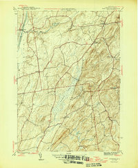
1946 Map of Hartford
USGS Topo · Published 1946About this map
The Barge Canal defines the western edge of this mid-century Washington County landscape, where the flat lowlands of the canal corridor transition abruptly into a series of named ridges and summits. Agricultural and rural life centers on the villages of Hartford, South Hartford, and Belcher, connected by a network of winding roads that skirt the large Tamarack Swamp and follow the course of Big Creek. Genealogists will find valuable markers at the Adamsville Cem and can trace the locations of rural schoolhouses like the Salem Sch in the southeast.
Find a feature on this map
25 named features on this map. Tap any name to fly to it.
Don’t see what you’re looking for? This feature index may not catch every label — zoom into the map to look around manually.
Map Details
Editions of this 1946 Hartford Map
This is the sole edition of this map. No revisions or reprints were ever made.
Other maps of this area

1893 · Fort Ann
USGS Topo · 1:62,500

1895 · Cambridge
USGS Topo · 1:62,500

1895 · Fort Ann
USGS Topo · 1:62,500

1895 · Glens Falls
USGS Topo · 1:62,500

1897 · Glens Falls
USGS Topo · 1:62,500

1898 · Cambridge
USGS Topo · 1:62,500

1898 · Fort Ann
USGS Topo · 1:62,500

1900 · Schuylerville
USGS Topo · 1:62,500

1901 · Fort Ann
USGS Topo · 1:62,500

1901 · Cambridge
USGS Topo · 1:62,500