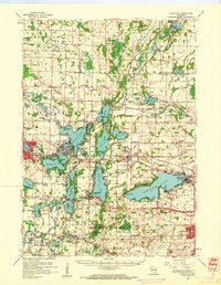
1959 Map of Hartland
USGS Topo · Published 1961About this map
The Oconomowoc River and Bark River systems define this 1950s landscape, winding through a dense network of glacial lakes including Okauchee Lake, Nagawicka Lake, and Pewaukee Lake. The region's development is centered on the Chicago and North Western and Chicago Milwaukee St Paul and Pacific railroads, which connected established villages like Hartland, Delafield, and Oconomowoc. This survey reveals a transition from traditional rural life to a burgeoning recreational and residential corridor, evidenced by the numerous named schools such as Arrowhead High Sch and University Lake Sch appearing alongside long-standing landmarks like St Olaf Ch and St Catherine Ch. In the southern portion, the Kettle Moraine State Forest surrounds Lapham Peak, while Cushing Memorial State Park serves as a notable historic marker near Delafield. The map also captures numerous localized features, including multiple Gravel Pits and cemeteries like Ashippun Cem and St Johns Cem, which offer significant value for genealogical research.
Find a feature on this map
110 named features on this map. Tap any name to fly to it.
Don’t see what you’re looking for? This feature index may not catch every label — zoom into the map to look around manually.
Map Details
Editions of this 1959 Hartland Map
This is the sole edition of this map. No revisions or reprints were ever made.
Other maps of this area

1891 · Muskego
USGS Topo · 1:62,500

1892 · Waukesha
USGS Topo · 1:62,500

1892 · Watertown
USGS Topo · 1:62,500

1892 · Oconomowoc
USGS Topo · 1:62,500

1892 · Whitewater
USGS Topo · 1:62,500

1892 · Eagle
USGS Topo · 1:62,500

1893 · Whitewater
USGS Topo · 1:62,500

1894 · Watertown
USGS Topo · 1:62,500

1894 · Eagle
USGS Topo · 1:62,500

1897 · Eagle
USGS Topo · 1:62,500