
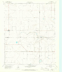
1963 Map of Hartley NE
USGS Topo · Published 1966About this map
The High Plains of the Texas Panhandle near the Hartley NE quadrangle reveal a landscape shaped by mid-century water management and energy infrastructure. This 1963 survey, produced in cooperation with the Texas Water Development Board, highlights a terrain punctuated by numerous depressions and catchments, reflecting the region's reliance on underground resources. Scattered Wells are mapped across the area, indicating the vital role of groundwater extraction for agricultural or ranching operations in this part of Hartley County. The presence of a significant Pipeline cutting diagonally across the landscape underscores the industrial development and transport networks that characterized the region's economic growth during the early 1960s. These minimal but essential features provide a clear picture of the functional, resource-driven settlement patterns common in the rural Panhandle during this era.
Find a feature on this map
2 named features on this map. Tap any name to fly to it.
Don’t see what you’re looking for? This feature index may not catch every label — zoom into the map to look around manually.
Map Details
Editions of this 1963 Hartley NE Map
This is the sole edition of this map. No revisions or reprints were ever made.
Other maps of this area

1954 · Tucumcari
USGS Topo · 1:250,000

1954 · Dalhart
USGS Topo · 1:250,000

1958 · Tucumcari
USGS Topo · 1:250,000

1958 · Dalhart
USGS Topo · 1:250,000

1962 · Dalhart
USGS Topo · 1:250,000

1963 · Hartley SE
USGS Topo · 1:24,000

1963 · Bird Ranch Store
USGS Topo · 1:24,000

1963 · Moran Ranch
USGS Topo · 1:24,000

1965 · Wilco
USGS Topo · 1:24,000
1965 · Exum
USGS Topo · 1:24,000