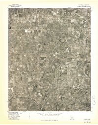
1977 Map of Hartville
USGS Topo · Published 1977About this map
Hartville and the surrounding Wright County countryside are captured in this 1977 orthophotoquad, which utilizes rectified aerial imagery to document the rural landscape in high detail. The map provides a direct visual record of land use patterns, showing the patchwork of agricultural fields, dense wooded creek bottoms, and the winding road network of the late 1970s. This aerial perspective, prepared in cooperation with the Soil Conservation Service, highlights the small settlement of Odin to the southwest, situated along the undulating terrain that defines this part of the Missouri Ozarks. Unlike a standard topographic line map, this photographic representation allows for the identification of individual structures, farmsteads, and the specific density of forest cover that existed during the spring of 1977.
Find a feature on this map
2 named features on this map. Tap any name to fly to it.
Don’t see what you’re looking for? This feature index may not catch every label — zoom into the map to look around manually.
Map Details
Editions of this 1977 Hartville Map
This is the sole edition of this map. No revisions or reprints were ever made.
Other maps of this area

1931 · Manes
USGS Topo · 1:48,000

1941 · Manes
USGS Topo · 1:62,500

1943 · Manes
USGS Topo · 1:62,500

1951 · Owens
USGS Topo · 1:24,000

1951 · Mansfield NE
USGS Topo · 1:24,000

1951 · Mansfield NW
USGS Topo · 1:24,000

1951 · Mountain Grove
USGS Topo · 1:62,500

1954 · Springfield
USGS Topo · 1:250,000

1956 · Duncan
USGS Topo · 1:24,000

1956 · Rader
USGS Topo · 1:24,000