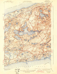
1943 Map of Harwich
USGS Topo · Published 1943About this map
The glacial kettle ponds of the mid-Cape dominate this landscape during the early 1940s, with Long Pond and Seymour Pond forming a massive freshwater chain between Brewster and Harwich. The map reveals a transition from the denser coastal villages of Harwich Port and West Harwich to the interior pond-strewn woodlands now preserved in Nickerson State Park. Transportation at this time is defined by the New York New Haven and Hartford RR, which snakes through the interior near Pleasant Lake and North Harwich. Local institutions such as the Sea Pine Sch and the Brewster Country Club appear alongside family-named landmarks like Smith Pond and the Dillingham Cem. The map's detail of the Cape's shoreline includes landmarks like Witchmere Harbor and Allens Harbor, reflecting the region's long-standing connection to Nantucket Sound before mid-century development accelerated.
Find a feature on this map
106 named features on this map. Tap any name to fly to it.
Don’t see what you’re looking for? This feature index may not catch every label — zoom into the map to look around manually.
Map Details
Editions of this 1943 Harwich Map
3 editions found
Other maps of this area

1887 · Wellfleet
USGS Topo · 1:62,500

1887 · Yarmouth
USGS Topo · 1:62,500

1888 · Chatham
USGS Topo · 1:62,500

1889 · Yarmouth
USGS Topo · 1:62,500

1889 · Wellfleet
USGS Topo · 1:62,500

1893 · Chatham
USGS Topo · 1:62,500

1893 · Yarmouth
USGS Topo · 1:62,500

1893 · Wellfleet
USGS Topo · 1:62,500

1917 · Chatham
USGS Topo · 1:62,500

1942 · Cape Cod Bay
USGS Topo · 1:125,000