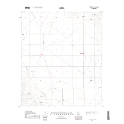
2020 Map of Hatchet Ranch
USGS Topo · Published 2020About this map
Hatchet Ranch sits at the heart of this high-desert landscape in Hidalgo County, where the southern reaches of the Hachita Valley meet the rising slopes of the Big Hatchet Mountains. This area is defined by its arid hydrology and complex terrain, featuring numerous catchments like Dishpan Tank and Batter Tank that are essential for supporting life and ranching in the Chihuahuan Desert. The topographic detail reveals a network of rugged canyons including Horse Pasture Canyon and Dark Canyon, alongside notable geological formations such as Sierra Rica and Ram Gorge. A significant portion of the Continental Divide National Scenic Trail winds through the southwestern corner, tracing the spine of the mountains. The road network is sparse, centered on Commodore Rd and Hatchet Rd, highlighting the remote character of this borderlands region.
Find a feature on this map
26 named features on this map. Tap any name to fly to it.
Don’t see what you’re looking for? This feature index may not catch every label — zoom into the map to look around manually.
Map Details
Editions of this 2020 Hatchet Ranch Map
This is the sole edition of this map. No revisions or reprints were ever made.
Other maps of this area

1918 · Big Hatchet Peak
USGS Topo · 1:62,500

1918 · Hachita
USGS Topo · 1:62,500

1918 · Victorio
USGS Topo · 1:62,500

1955 · Douglas
USGS Topo · 1:250,000

1959 · Douglas
USGS Topo · 1:250,000

1961 · Douglas
USGS Topo · 1:250,000

1964 · Douglas
USGS Topo · 1:250,000
1965 · Victorio Ranch
USGS Topo · 1:24,000
1982 · Doyle Peak
USGS Topo · 1:24,000
1982 · Big Hatchet Peak
USGS Topo · 1:24,000