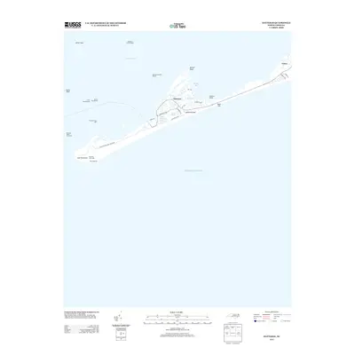
2013 Map of Hatteras
USGS Topo · Published 2013About this map
Hatteras Island forms a narrow, vulnerable ribbon of land between the Pamlico Sound and the Atlantic Ocean in this coastal survey. The settlement of Hatteras sits at the heart of the island, where local roads like Flambeau Rd and Lighthouse Rd serve a community bounded by water. To the west, the Inlet Peninsula terminates near the historic site of Fort Hatteras, a critical point of maritime defense. The landscape is defined by its transition from the built environment to the protected dunes of the Cape Hatteras Natl Seashore.
Find a feature on this map
32 named features on this map. Tap any name to fly to it.
Don’t see what you’re looking for? This feature index may not catch every label — zoom into the map to look around manually.
Map Details
Editions of this 2013 Hatteras Map
This is the sole edition of this map. No revisions or reprints were ever made.
Other maps of this area

1948 · Cape Hatteras
USGS Topo · 1:24,000

1948 · Buxton
USGS Topo · 1:24,000

1950 · Cape Hatteras
USGS Topo · 1:24,000

1950 · Buxton
USGS Topo · 1:24,000
1950 · Green Island
USGS Topo · 1:24,000

1955 · Wanchese
USGS Topo · 1:250,000

1957 · Manteo
USGS Topo · 1:250,000

1960 · Manteo
USGS Topo · 1:250,000

1985 · Cape Hatteras
USGS Topo · 1:100,000

2002 · Cape Hatteras
USGS Topo · 1:24,000