Old Maps of Dare County, North Carolina
Explore 212 old maps of Dare County, spanning from 1940 to today. These high-resolution historic maps reveal how streets, neighborhoods, landmarks, and natural features evolved over time — perfect for genealogy, metal detecting, research, and local history exploration.
What you can do with these maps:
- See how Dare County changed over time: Compare historical maps to modern-day views to trace roads, homesites, rail lines & more.
- View detailed metadata: Each map includes creators, publishers, year, scale, and archive source.
- Overlay maps with satellite & LiDAR: Visualize the past alongside modern tools to explore terrain & human change.
- Trusted historical sources: Maps sourced from the USGS, Library of Congress, and other archives.
- Access maps your way: View online, download high-res files, or order prints for personal or research use.
Start exploring old maps of Dare County to uncover forgotten places, hidden landmarks, and the deep history beneath your feet.
Dare County, NC maps
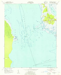
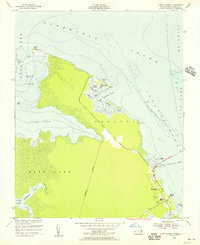
(212)- 1940 Map of Kitty Hawk
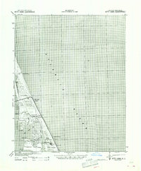 1940 Kitty Hawk1940 Print · USGSThe Outer Banks are captured here in the early 1940s, showing a landscape defined by maritime history and the early years of flight commemoration. Trace the grounds of the Wright Monument and locate small coastal settlements like Eagleton and Sound Landing.2 unique versions available
 - 1940 Map of Powells Point
 1940 Powells Point1940 Print · USGSThe North Carolina coast at the start of the 1940s shows the Currituck peninsula just as the Wright Memorial Bridge opened it to more travel. Trace family roots and old landings in Jarvisburg, Powells Point, and Sawyers Lodge.2 unique versions available
 - 1943 Map of Columbia
 1943 Columbia1943 Print · USGSCoastal Tyrrell and Hyde Counties are captured in the early 1940s, showing a landscape defined by timber industry and federal land projects. Researchers can trace the industrial docks at the Richmond Cedar Works Lumber Mill or locate the rural Scuppernong Farms (F.S.A.).
 - 1943 Map of Roanoke Island
 1943 Roanoke Island1943 Print · USGSCoastal North Carolina during the war years shows a network of maritime outposts and isolated mainland settlements connected by ferry. Trace the old village of Buffalo City, locate the Bodie Island Lighthouse, and find historic Coast Guard stations at Nags Head and Chicamacomico CG.
 - 1946 Map of Eastville, 1971 Print
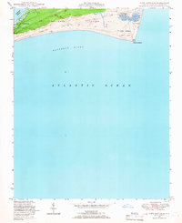
 1946 Eastville1971 Print · USGSCoastal Virginia and the Outer Banks are captured here during a period of expanding naval and aerospace presence. Researchers can trace the path of the Penn Central railroad through Chincoteague and Modest Town, or locate landmarks like the Wright Brothers National Memorial.
 - 1946 Map of Currituck Sound, 1980 Print
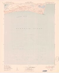
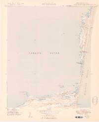
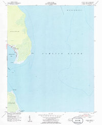
 1946 Currituck Sound1980 Print · USGSThe Virginia and North Carolina coastline appears in detail during the mid-twentieth century as a network of maritime villages and military outposts. Genealogists and local historians can trace family locations from Virginia Beach south to Kitty Hawk, including landmarks like the Currituck Beach Lighthouse and the Wright Brothers National Memorial.
 - 1948 Map of Cape Hatteras, 1966 Print
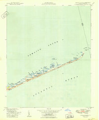
 1948 Cape Hatteras1966 Print · USGSThe Outer Banks come to life in the late 1940s as this survey captures the maritime landscape of Hatteras Island. Genealogists and historians can trace the early footprints of Frisco or locate the Little Grove Ch and Cape Hatteras Coast Guard Sta before the region's modern development.3 unique versions available
 - 1948 Map of Buxton, 1968 Print
 1948 Buxton1968 Print · USGSHatteras Island is captured here in the late 1940s, showing the delicate balance of the Outer Banks before the era of major tourism. Trace the history of maritime navigation through the abandoned lighthouse and the village of Avon.4 unique versions available
 - 1950 Map of Cape Hatteras
 1950 Cape Hatteras1950 Print · USGSThe Outer Banks come to life in this mid-century survey of the North Carolina coast during a period of transition for its maritime communities. Trace the shoreline from Frisco to Cape Point, locating landmarks like Little Grove Ch and the Coast Guard Sta.2 unique versions available
 - 1950 Map of Buxton
 1950 Buxton1950 Print · USGSThe Outer Banks come alive in this mid-century survey of Hatteras Island as it appeared before modern development. You can trace early maritime history through landmarks like the Cape Hatteras Lighthouse and the small coastal village of Avon.2 unique versions available
 - 1950 Map of Green Island
 1950 Green Island1950 Print · USGSOcracoke Island and the Outer Banks are captured mid-century, showing a landscape defined by shifting sands and maritime service. Trace the isolation of the Hatteras Inlet Coast Guard Sta and local camps like the Old Green Island Club.3 unique versions available
 - 1951 Map of Long Shoal Point, 1953 Print
 1951 Long Shoal Point1953 Print · USGSThe Outer Banks coastline near the Hyde and Dare county line is captured in the early 1950s, showing a landscape defined by water and wetlands. Genealogists and maritime historians can trace coastal landmarks like the Lookout Tower, Pains Point, and Rawls Island.2 unique versions available
 - 1951 Map of Engelhard East, 1953 Print
 1951 Engelhard East1953 Print · USGSThe coastal village of Engelhard stands at the edge of the sound during the early 1950s, surrounded by a complex network of marshes and tidal creeks. Researchers can trace the maritime geography of Berrys Bay and family-named landmarks like Pingleton Point and Gibbs Point.4 unique versions available
 - 1953 Map of Wanchese, 1955 Print
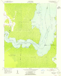
 1953 Wanchese1955 Print · USGSCoastal Dare County is shown here in the early fifties, focusing on the maritime culture of southern Roanoke Island. Genealogists and local historians can trace the early layout of Wanchese and Baumtown, locating Bethany Ch and the Roanoke Marshes Lighthouse.5 unique versions available
 - 1953 Map of Engelhard NW, 1955 Print
 1953 Engelhard NW1955 Print · USGSCoastal Dare and Hyde Counties are captured in the early fifties as a world of secluded marshes and tidal creeks. Researchers can trace the shifting county line through the wetlands between Whipping Creek Lake and the Long Shoal River.4 unique versions available
 - 1953 Map of Roanoke Island NE, 1955 Print
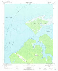
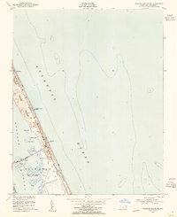 1953 Roanoke Island NE1955 Print · USGSThe Outer Banks come to life in this mid-century portrait of a changing coastline and its early maritime infrastructure. Trace the early layout of Nags Head including the U S Coast Guard Station, Jeanettes Pier, and the island-hopping Causeway.6 unique versions available
 - 1953 Map of Buffalo City, 1955 Print
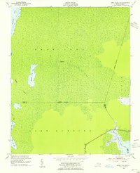
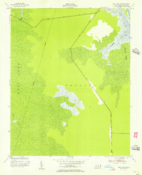
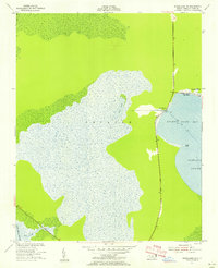
 1953 Buffalo City1955 Print · USGSThe Dare County mainland in the early fifties is a landscape of expansive wetlands and remote outposts. Researchers can trace the isolated settlement of Buffalo City and identify family-named landmarks like Raccoon Point and Beach Land Landing.3 unique versions available
 - 1953 Map of Fairfield NE, 1955 Print
 1953 Fairfield NE1955 Print · USGSCoastal Tyrrell County in the early fifties is defined by the winding Alligator River and its labyrinth of marshy points. Genealogists and local historians can trace the settlement at Gum Neck or locate specific waterfront access at Gum Neck Landing and Grapevine Landing.3 unique versions available
 - 1953 Map of Stumpy Point, 1956 Print
 1953 Stumpy Point1956 Print · USGSCoastal Dare County at the start of the fifties reveals a maritime community deeply connected to the sound. Genealogists and historians can trace the foundations of the village at Stumpy Point, locating family sites at Shiloh Church Cem and Shiloh Ch.2 unique versions available
 - 1953 Map of Manteo, 1956 Print
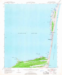
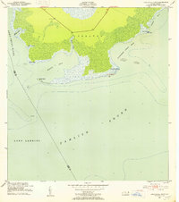
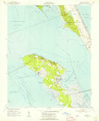 1953 Manteo1956 Print · USGSRoanoke Island and the Outer Banks are captured here in the early fifties, before decades of intensive coastal development. Genealogists and historians can trace family-named sites like Mother Vineyard and the early layout of Manteo and Skyco.5 unique versions available
 - 1953 Map of East Lake SE, 1956 Print
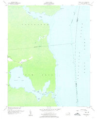
 1953 East Lake SE1956 Print · USGSCoastal Dare County in the early fifties is captured here as modern highways began to bridge the deep wetlands. Researchers can trace the water-dependent landscape of Roanoke Marsh and winding inlets like Callaghan Creek and Hooker Gut.3 unique versions available
 - 1953 Map of Manns Harbor, 1956 Print
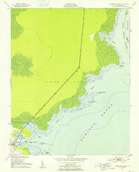
 1953 Manns Harbor1956 Print · USGSThe Dare County coastline in the early fifties shows a region on the cusp of change as new roads were built to connect the mainland to the banks. Trace the old Ferry Route from Manns Harbor or locate family landmarks like Mt Carmel Ch and Fleetwood Point.2 unique versions available
 - 1953 Map of East Lake, 1956 Print
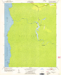
 1953 East Lake1956 Print · USGSCoastal Dare County in the early fifties shows a landscape of isolated shorelines and small water-bound communities. Trace family roots and local history through East Lake Landing, the ruins at Lake Neighborhood, and the Ferry crossing the Alligator River.3 unique versions available
 - 1953 Map of Engelhard NE, 1956 Print
 1953 Engelhard NE1956 Print · USGSCoastal Dare County at mid-century reveals a landscape shaped by the sounds and marshlands of the Outer Banks. Genealogists and historians can trace the small community at Stumpy Point, find the Full Gospel Tabernacle, and locate landmarks like Lake Worth.3 unique versions available
 - 1953 Map of Frying Pan, 1956 Print
 1953 Frying Pan1956 Print · USGSThe swampy peninsulas and river inlets of Tyrrell County are captured here in the mid-1950s. Genealogists and local historians can trace family locations near Frying Pan, Free Union Ch, and the landings along the Alligator River.3 unique versions available
Showing maps 1-25 of 212
Top cities of Dare County
- Kill Devil Hills historical maps
- Kitty Hawk historical maps
- Nags Head historical maps
- Southern Shores historical maps
- Wanchese historical maps
- Manteo historical maps
See more
Frequently asked questions
- What are the different types of historical maps available for Dare County?
- What is the oldest map of Dare County?
- Where can I purchase historical maps of Dare County for my home or office?
- Where can I download high-res historical maps of Dare County?
- Are there historical topographic maps available for Dare County?
- Is there historical aerial imagery available for Dare County?
- Where are historical maps of Dare County sourced from?