
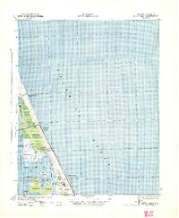
1940 Map of Kitty Hawk
USGS Topo · Published 1940About this map
Wright Memorial Monument 151 stands as a prominent landmark on Killdevil Hill in this coastal landscape, surveyed just before the United States entered the second World War. The map captures the Outer Banks when settlements like Kitty Hawk and Colington were small, isolated communities defined by their proximity to the Currituck Sound and the Atlantic Ocean. The presence of several coast guard stations, including Paul Gamiels Hill C G 171 and C G 172, underscores the maritime safety and military monitoring essential to this stretch of the Carolina coast during the era. The intricate network of waterways like Jean Guite Creek and Collington Creek separates landforms such as Colington Island and Burnt Island, illustrating a terrain where travel was dictated by the tides and sounds.
Find a feature on this map
30 named features on this map. Tap any name to fly to it.
Don’t see what you’re looking for? This feature index may not catch every label — zoom into the map to look around manually.
Map Details
Editions of this 1940 Kitty Hawk Map
2 editions found
Other maps of this area

1940 · Barco
USGS Topo · 1:62,500

1940 · Powells Point
USGS Topo · 1:62,500

1943 · Roanoke Island
USGS Topo · 1:125,000

1946 · Eastville
USGS Topo · 1:250,000

1946 · Currituck Sound
USGS Topo · 1:250,000

1953 · Roanoke Island NE
USGS Topo · 1:24,000

1953 · Manteo
USGS Topo · 1:24,000

1953 · Manns Harbor
USGS Topo · 1:24,000

1955 · Wanchese
USGS Topo · 1:250,000

1957 · Manteo
USGS Topo · 1:250,000