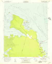
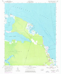
1953 Map of Manns Harbor
USGS Topo · Published 1956About this map
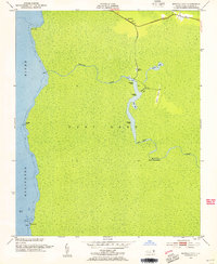
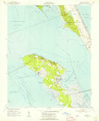
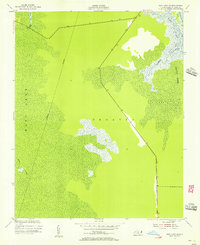
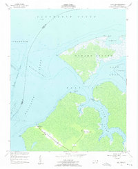
Manns Harbor sits at the eastern edge of a transition between the expansive open waters of the Albemarle Sound and the intricate wetlands surrounding East Lake. This mid-century coastal survey documents a landscape defined by water and marsh, where small settlements like Mashoes Marsh are anchored by local landmarks such as Mt Mitchell Ch. To the south, the village of Manns Harbor is depicted just as modern infrastructure begins to reshape the Outer Banks region, with a road marked Under Construction heading toward a Ferry Route that crosses Croatan Sound. The map reveals the hydrography of the interior, including the Northeast Prong and Hooker Gut, providing a detailed look at the drainage patterns of the mainland before major land-use changes. It captures a moment when travel still relied heavily on the water, evidenced by the scattered lights and pilings along the sound.
Find a feature on this map
34 named features on this map. Tap any name to fly to it.
Don’t see what you’re looking for? This feature index may not catch every label — zoom into the map to look around manually.
Map Details
Editions of this 1953 Manns Harbor Map
2 editions found
Other maps of this area
1940 · Kitty Hawk
USGS Topo · 1:62,500

1940 · Powells Point
USGS Topo · 1:62,500

1943 · Roanoke Island
USGS Topo · 1:125,000

1946 · Eastville
USGS Topo · 1:250,000

1946 · Currituck Sound
USGS Topo · 1:250,000
1953 · Wanchese
USGS Topo · 1:24,000
1953 · Buffalo City
USGS Topo · 1:24,000
1953 · Manteo
USGS Topo · 1:24,000
1953 · East Lake SE
USGS Topo · 1:24,000
1953 · East Lake
USGS Topo · 1:24,000