1980s Maps of Dare County, North Carolina
Explore 8 historic maps of Dare County from the 1980s. These maps offer a rare glimpse into what life looked like during the 1980s — showing old roads, neighborhoods, homes, and landmarks that have changed or disappeared over time.
Whether you're researching your family's past, planning a metal detecting trip, or studying how Dare County's landscape evolved across the 1980s, these high-resolution maps are a powerful tool for exploring the history of this region.
- Focus on a specific era: All maps on this page are from the 1980s, giving you a focused view of this time period.
- See what’s changed: Compare century-old streets, trails, and buildings to today's modern landscape using overlays and satellite layers.
- Research with precision: Use these maps for genealogy, historical research, land use analysis, or educational projects.
- View, download, or print: Maps are fully viewable online in high resolution, and can be downloaded or printed for your own records.
Start exploring Dare County's history through authentic maps from the 1980s. This is your window into the past.
Dare County, NC maps
(8)- 1982 Map of Jarvisburg, 1983 Print
 1982 Jarvisburg1983 Print · USGSThe Currituck Banks and mainland neck are captured in the early eighties as coastal development began to accelerate. Genealogists and researchers can locate numerous community landmarks, from Hebron Ch to the small settlements of Olds and Mamie.
 - 1982 Map of Kitty Hawk, 1983 Print
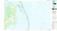
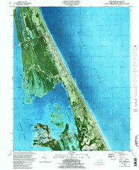 1982 Kitty Hawk1983 Print · USGSThe Outer Banks come into focus in the early eighties as coastal communities and landmarks like the Wright Brothers Nat Mem define the landscape. Trace the development of Kitty Hawk and Colington, and locate family sites like Austin Cem or Hilltop Cem.
 - 1982 Map of Point Harbor, 1983 Print
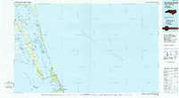
 1982 Point Harbor1983 Print · USGSThe Currituck peninsula at the start of the eighties is captured here at the junction of two sounds. Trace local family history through community clusters at Harbinger and Spot, or locate landmarks like Hog Quarter Landing.
 - 1982 Map of Martin Point, 1983 Print
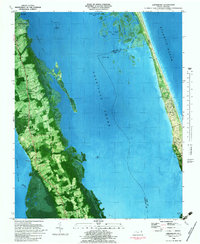
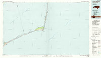
 1982 Martin Point1983 Print · USGSThe Outer Banks barrier islands are seen here in the early eighties as residential development began to reshape the coastline. Genealogists and historians can trace the footprints of Southern Shores and Duck, or locate landmarks like the local Fire House and Jean Guite Cr.
 - 1985 Map of Currituck Sound
 1985 Currituck Sound1985 Print · USGSThe Outer Banks and Currituck Sound are documented in the mid-1980s, during a period of steady coastal growth and preservation. Researchers can locate long-standing maritime landmarks like the Currituck Beach Lighthouse and trace the original footprints of settlements from Corolla to Kitty Hawk.2 unique versions available
 - 1985 Map of Cape Hatteras
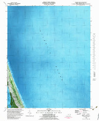
 1985 Cape Hatteras1985 Print · USGSThe Outer Banks are captured in the mid-eighties as a thin ribbon of sand between the sound and the sea. Trace the coastal communities of Ocracoke and Buxton, the Ferry route across Hatteras Inlet, and the Cape Hatteras Lighthouse.2 unique versions available
 - 1985 Map of Manteo
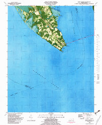
 1985 Manteo1985 Print · USGSThe Outer Banks and Roanoke Island appear in the mid-1980s, showcasing the early development of the modern coastal landscape. Researchers can trace family ties and coastal landmarks from Kill Devil Hills down to the remote village of Stumpy Point.2 unique versions available
 - 1985 Map of Plymouth
 1985 Plymouth1985 Print · USGSThe coastal plains of Washington and Beaufort counties come into focus in the mid-eighties as a region defined by large-scale conservation and water-bound trade. Researchers can trace the layout of small farming towns like Pantego and Creswell alongside the vast waters of Phelps Lake and Lake Mattamuskeet.2 unique versions available
End of results
Showing maps 1-8 of 8
Top cities of Dare County
- Kill Devil Hills historical maps
- Kitty Hawk historical maps
- Nags Head historical maps
- Southern Shores historical maps
- Wanchese historical maps
- Manteo historical maps
See more
Frequently asked questions
- What are the different types of historical maps available for Dare County?
- What is the oldest map of Dare County?
- Where can I purchase historical maps of Dare County for my home or office?
- Where can I download high-res historical maps of Dare County?
- Are there historical topographic maps available for Dare County?
- Is there historical aerial imagery available for Dare County?
- Where are historical maps of Dare County sourced from?