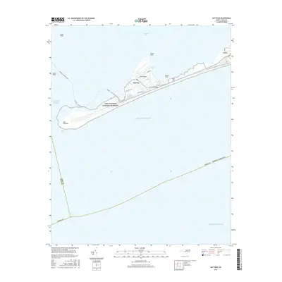
2016 Map of Hatteras
USGS Topo · Published 2016About this map
Hatteras Island forms the backbone of this coastal survey, documenting the thin ribbon of the Outer Banks between the Atlantic Ocean and Pamlico Sound. This 2016 snapshot captures the local infrastructure and natural landmarks of the Cape Hatteras National Seashore, where the narrow landscape is dominated by tidal features like The Slash, Duck Ponds, and Isaac Ponds. The settlements of Hatteras and Frisco are mapped in detail, showing their orientation along the island's single main thoroughfare and local connectors like Eagle Pass Rd and Lighthouse Rd. The map also traces the essential transit link of the Hatteras - Ocracoke Ferry crossing from the southwestern tip at Inlet Peninsula. Navigation hazards and coastal terrain are identified by name, including Oliver Reef, Austin Reef, and Durant Point, reflecting the maritime character of this exposed barrier island environment.
Find a feature on this map
26 named features on this map. Tap any name to fly to it.
Don’t see what you’re looking for? This feature index may not catch every label — zoom into the map to look around manually.
Map Details
Editions of this 2016 Hatteras Map
This is the sole edition of this map. No revisions or reprints were ever made.
Other maps of this area

1948 · Cape Hatteras
USGS Topo · 1:24,000

1948 · Buxton
USGS Topo · 1:24,000

1950 · Cape Hatteras
USGS Topo · 1:24,000

1950 · Buxton
USGS Topo · 1:24,000
1950 · Green Island
USGS Topo · 1:24,000

1955 · Wanchese
USGS Topo · 1:250,000

1957 · Manteo
USGS Topo · 1:250,000

1960 · Manteo
USGS Topo · 1:250,000

1985 · Cape Hatteras
USGS Topo · 1:100,000

2002 · Cape Hatteras
USGS Topo · 1:24,000