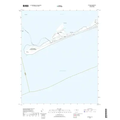
2019 Map of Hatteras
USGS Topo · Published 2019About this map
Hatteras Island stretches narrowly between the Atlantic Ocean and Pamlico Sound, defined by its dynamic maritime geography and established coastal villages. The settlements of Hatteras and Frisco are linked by coastal roads like Kohler Rd and Eagle Pass Rd, while the Hatteras - Ocracoke Ferry route marks the essential maritime connection to the south across Hatteras Inlet. Much of the landscape is protected within the Cape Hatteras National Seashore, where the terrain transitions from the dunes of Bare Hill to the interior wetlands of The Slash, Duck Ponds, and Isaac Ponds. This 2019 survey provides a precise view of the barrier island's configuration, showing the proximity of shoals and reefs like Austin Reef and Oliver Reef to the vital navigable waters that have shaped the economy and culture of the Outer Banks.
Find a feature on this map
24 named features on this map. Tap any name to fly to it.
Don’t see what you’re looking for? This feature index may not catch every label — zoom into the map to look around manually.
Map Details
Editions of this 2019 Hatteras Map
This is the sole edition of this map. No revisions or reprints were ever made.
Other maps of this area

1948 · Cape Hatteras
USGS Topo · 1:24,000

1948 · Buxton
USGS Topo · 1:24,000

1950 · Cape Hatteras
USGS Topo · 1:24,000

1950 · Buxton
USGS Topo · 1:24,000
1950 · Green Island
USGS Topo · 1:24,000

1955 · Wanchese
USGS Topo · 1:250,000

1957 · Manteo
USGS Topo · 1:250,000

1960 · Manteo
USGS Topo · 1:250,000

1985 · Cape Hatteras
USGS Topo · 1:100,000

2002 · Cape Hatteras
USGS Topo · 1:24,000