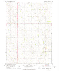
1978 Map of Haucks Lake
USGS Topo · Published 1979About this map
Emanuel Creek and its tributary Little Emanuel Creek carve a network of drainages through this section of Bon Homme County in the late 1970s. The landscape is primarily defined by a geometric grid of rural roads and land sections, punctuated by vital community institutions like Danzig Ch Cem and Immanuel Cem. The presence of Dewald Sch and Hoff Sch suggests the persistence of localized rural school districts that once anchored these prairie townships. Near the center of the map, Haucks Lake provides a notable water feature amidst the agrarian expanse. Small-scale resource extraction is evident through scattered Gravel Pits, while a lone Substation in the southeast corner points to the infrastructure supporting the surrounding farmsteads. This survey documents the quiet, enduring character of South Dakota's rural heartland during a period of steady agricultural tradition.
Find a feature on this map
18 named features on this map. Tap any name to fly to it.
Don’t see what you’re looking for? This feature index may not catch every label — zoom into the map to look around manually.
Map Details
Editions of this 1978 Haucks Lake Map
This is the sole edition of this map. No revisions or reprints were ever made.
Other maps of this area

1898 · Olivet
USGS Topo · 1:125,000

1955 · Sioux City
USGS Topo · 1:250,000

1955 · Sioux Falls
USGS Topo · 1:250,000

1955 · Mitchell
USGS Topo · 1:250,000

1955 · O'Neill
USGS Topo · 1:250,000

1958 · Sioux City
USGS Topo · 1:250,000

1958 · Sioux Falls
USGS Topo · 1:250,000

1959 · O'Neill
USGS Topo · 1:250,000

1959 · Sioux City
USGS Topo · 1:250,000

1959 · Mitchell
USGS Topo · 1:250,000
Featured Places
- Avon Township, SD
- Monroe Township, SD
- Emanuel Township, SD
- Franklin Township, SD
- Dawson Hutterite Colony, SD