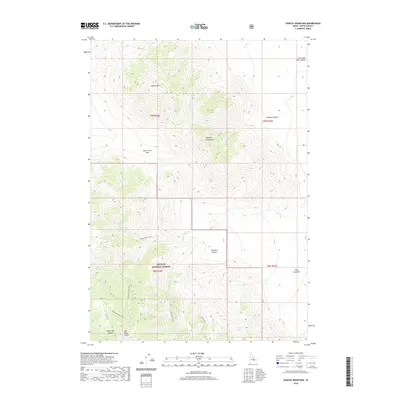
2020 Map of Hawley Mountain
USGS Topo · Published 2020About this map
Hawley Mtn and the Hawley Mountains dominate this high-altitude landscape in the Lost River Range. The terrain is defined by steep elevation changes and significant drainage systems, with Shark Creek and Deer Cr carving through the canyons. This portion of the Challis National Forest remains largely undeveloped, characterized by remote mountain passes and canyons. Researchers can identify the structural geography of the Little Lost River Valley and trace the paths of historic routes such as Mikes Trail as it winds through the southern ridges. Notable topographical landmarks like Deer Creek Pass and the Deer Creek Bar indicate the complex geological and hydrological history of this Butte County region, where the intersection of high peaks and deep canyons like Black Tail Canyon dictates the flow of water toward Blacktail/Mud Lake.
Find a feature on this map
20 named features on this map. Tap any name to fly to it.
Don’t see what you’re looking for? This feature index may not catch every label — zoom into the map to look around manually.
Map Details
Editions of this 2020 Hawley Mountain Map
This is the sole edition of this map. No revisions or reprints were ever made.
Other maps of this area

1955 · Dubois
USGS Topo · 1:250,000

1955 · Idaho Falls
USGS Topo · 1:250,000

1957 · Diamond Peak
USGS Topo · 1:62,500

1957 · Hawley Mountain
USGS Topo · 1:62,500

1958 · Dubois
USGS Topo · 1:250,000

1958 · Idaho Falls
USGS Topo · 1:250,000

1969 · Howe NW
USGS Topo · 1:24,000

1969 · Sunset Peak
USGS Topo · 1:24,000
1969 · Methodist Creek
USGS Topo · 1:24,000
1987 · Mulkey Bar
USGS Topo · 1:24,000