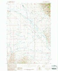
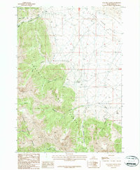
1987 Map of Mulkey Bar
USGS Topo · Published 1987About this map
Challis National Forest borders the northeastern corner of this high-elevation desert landscape where the borders of Butte, Custer, and Lemhi counties converge. The terrain is defined by broad alluvial fans and basins, including the namesake Mulkey Bar and the neighboring Deer Flats and Mud Flats. Water management is central to the human footprint here, visible in the network of irrigation and transport features like the Dry Creek Canal and Black Ditch that draw from the Little Lost River and its tributaries. These waterways, alongside Wet Creek and Sawmill Creek, suggest a complex history of ranching and agricultural efforts in an arid environment. Small-scale resource extraction is also noted by a Gravel Pit, providing evidence of local infrastructure development within this expansive valley system.
Find a feature on this map
19 named features on this map. Tap any name to fly to it.
Don’t see what you’re looking for? This feature index may not catch every label — zoom into the map to look around manually.
Map Details
Editions of this 1987 Mulkey Bar Map
This is the sole edition of this map. No revisions or reprints were ever made.
Other maps of this area

1955 · Dubois
USGS Topo · 1:250,000

1956 · Nicholia
USGS Topo · 1:62,500

1957 · Diamond Peak
USGS Topo · 1:62,500

1957 · Gilmore
USGS Topo · 1:62,500

1957 · Hawley Mountain
USGS Topo · 1:62,500

1958 · Dubois
USGS Topo · 1:250,000
1987 · Hawley Mountain
USGS Topo · 1:24,000
1987 · Warren Mountain
USGS Topo · 1:24,000
1987 · Bell Mountain
USGS Topo · 1:24,000
1987 · Coal Kiln Canyon
USGS Topo · 1:24,000